Kumar Bahukhandi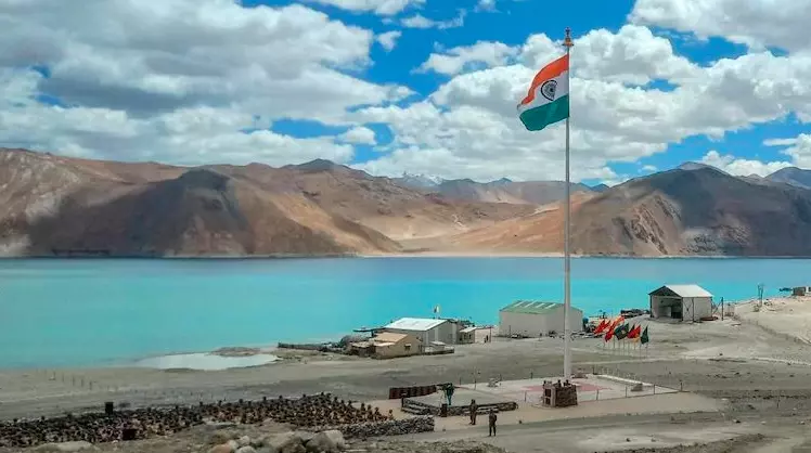
The Indian national flag flies beside the turquoise waters of Pangong Tso in Ladakh, a strategically significant Himalayan region along the India-China frontier, as Beijing objects to India’s standardisation of names for 28 geographical locations and New Delhi firmly reasserts its sovereignty on Tuesday, October 13, 2026.(Representational Image )
Beijing challenges New Delhi’s move to standardise geographical names in the sensitive Himalayan region, asserting territorial claims and maintaining that administrative naming decisions cannot alter the disputed boundary situation.
Key Highlights
- China objects to India’s decision to standardise names for 28 strategic locations and geographical features in Ladakh.
- Beijing claims that the areas concerned fall within territory claimed by China.
- Chinese authorities argue that naming decisions cannot change the existing border situation.
- The controversy brings renewed attention to the longstanding India-China boundary dispute.
- The development highlights the strategic importance of geographical identification, territorial claims and border administration.
New Delhi: China’s opposition to India’s decision to standardise the names of 28 strategic locations and geographical features in Ladakh has brought the sensitive Himalayan boundary dispute back into focus, with Beijing asserting territorial claims over the areas concerned and maintaining that New Delhi’s administrative action cannot change the situation along the disputed border. The development underscores the continuing differences between the two Asian powers over territorial sovereignty, geographical identification and the interpretation of their common frontier.
Beijing Challenges India’s Geographical Naming Decision
China has objected to India’s move to standardise the names of 28 locations and geographical features in Ladakh, describing the decision as inconsistent with Beijing’s territorial position.
The Chinese position rests on its claim that the areas involved belong to China, although such claims remain contested by India.
Beijing has argued that administrative measures, including the naming or renaming of geographical features, cannot determine sovereignty or alter the underlying territorial dispute.
The objection reflects the broader diplomatic sensitivity surrounding the Himalayan frontier, where competing territorial claims have historically complicated relations between the two countries.
The precise list of 28 locations and the individual geographical features covered by India’s decision have not been provided in the available account.
Ladakh Remains Central to India-China Border Disagreement
Ladakh occupies a strategically important position along India’s northern frontier, bordering areas administered or claimed by China and lying close to important military and logistical routes.
The region has long been central to disagreements over the Line of Actual Control (LAC), the de facto military boundary between India and China.
Unlike an internationally agreed and demarcated border, the LAC is subject to differing interpretations in several sectors.
These differences have contributed to recurring tensions, military stand-offs and diplomatic negotiations.
India administers Ladakh as a Union Territory and maintains its sovereignty claims over the region, while China contests sovereignty over certain areas.
China also controls Aksai Chin, which India claims as part of its territory.
Why Geographical Names Carry Strategic Significance
The standardisation of geographical names may appear to be an administrative exercise, but in disputed border regions it can carry considerable political and strategic significance.
Official names are used in government records, maps, navigation systems, geographical databases and administrative communications.
Consistent identification of locations can assist with mapping, infrastructure planning, emergency response and logistical coordination.
However, when geographical features lie within areas subject to competing territorial claims, naming decisions can become politically contentious.
Governments may interpret such measures as expressions of administrative authority or assertions of sovereignty.
China’s response to the Ladakh decision illustrates how even technical geographical measures can acquire diplomatic importance in sensitive border regions.
Naming Decisions Do Not Resolve Territorial Claims
International boundary disputes cannot ordinarily be settled through unilateral naming decisions alone.
Territorial sovereignty depends on a broader range of legal, historical, diplomatic and administrative considerations.
Consequently, neither India’s standardisation of geographical names nor China’s objections independently determine the legal status of disputed territory.
The present disagreement must therefore be understood within the larger context of unresolved boundary questions rather than as a development that changes territorial control.
For India, the identification and administration of geographical features within its claimed territory remain matters of national governance.
For China, the issue has become another occasion to reiterate its competing territorial position.
Border Stability Remains Important for Bilateral Relations
India and China have experienced periods of serious military tension along their Himalayan frontier, most notably following the deadly confrontation in the Galwan Valley in June 2020.
The incident demonstrated the risks associated with differing perceptions of the boundary and the deployment of military forces in contested areas.
Subsequent diplomatic and military-level discussions have sought to manage tensions and address friction points.
Nevertheless, the broader boundary dispute remains unresolved.
Against this background, disagreements over geographical naming can attract attention beyond their immediate administrative significance.
The controversy also demonstrates the importance of maintaining communication between the two countries while addressing differences through established diplomatic channels.
India’s Territorial Position and Strategic Interests
India’s approach to Ladakh is shaped by considerations of sovereignty, territorial integrity, border security and infrastructure development.
The region’s mountainous terrain, extreme weather conditions and geographical isolation make effective administration and logistical planning particularly important.
Standardised geographical identification can contribute to clearer official records and improved coordination across government agencies.
At the same time, disputes involving the identification of locations require careful diplomatic handling because the two countries maintain competing interpretations of certain border areas.
China’s objection does not, by itself, invalidate India’s administrative decision, just as India’s naming exercise does not settle the underlying territorial disagreement.
Diplomatic Differences Persist Despite Efforts to Stabilise Relations
The latest objection reflects the continuing sensitivity of territorial questions in India-China relations.
Both countries have substantial economic and geopolitical interests, making stability along the Himalayan frontier important for regional security.
However, differences over sovereignty and the interpretation of the border remain significant obstacles to a comprehensive settlement.
The dispute over the 28 locations illustrates how geographical terminology can become part of a wider contest over territorial narratives.
Ultimately, the significance of the naming decision lies not merely in the names themselves but in the competing sovereignty claims they have brought into renewed public discussion.
India’s administrative decisions and China’s territorial objections must be assessed against the established positions of both governments, while the unresolved boundary dispute continues to require diplomatic engagement, military restraint and a mutually acceptable settlement.
India Rejects China’s Objection, Reaffirms Sovereignty Over Ladakh
In a firm diplomatic response on Tuesday, October 13, India’s Ministry of External Affairs rejected Beijing’s objections and reiterated that Ladakh remains an integral and inalienable part of India.
MEA spokesperson Randhir Jaiswal declared:
“No amount of denial by the Chinese side can change this established fact.”
Jaiswal explained that the 28 locations had been formally identified on the Survey of India map following consultations with the Ladakh administration and local stakeholders. The exercise was intended to improve accurate geographical recognition and public awareness.
China’s Foreign Ministry spokesperson Mao Ning, meanwhile, described India’s action as “illegal and void” and reiterated Beijing’s refusal to recognise the Union Territory of Ladakh.
India’s response makes clear that New Delhi rejects Beijing’s objections and maintains its established position on Ladakh’s territorial status.